


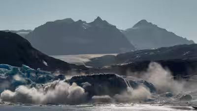
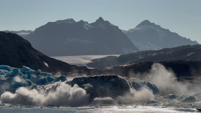
Scientists aboard Britain’s flagship polar research vessel, RRS Sir David Attenborough, watched an estimated 18 million metric tonnes of ice crash into the ocean when a massive section of Greenland’s Sorgenfri glacier broke away in a single evening event.The ice wall measured one kilometre wide and averaged 100 metres thick. According to a news story released by the British Antarctic Survey (BAS), the crew and researchers captured footage of the collapse near the head of 3-miippugut Fjord, north of Kangerlussuaq Fjord in East Greenland.Captain Matt Neill, Master of the RRS Sir David Attenborough, described the manoeuvre needed to keep the ship clear of the sudden wave caused by the collapse.“At the time of calving, our ship was more than a kilometre away from the front of the glacier,” said Captain Neill. “Both the ship and our crew are well prepared to respond to events like this. As we saw the calving begin, we were able to quickly turn the ship into the safest position. It was incredible to see such a volume of ice shifting, and a reminder of the importance of the work we’re here to do.”While glacier calving happens naturally as glaciers that end in the ocean change during the summer months, Greenland’s ice sheet continues to lose total mass at record rates.
Mapping the Atlantic ocean conveyor belt
The collapse happened during the field phase of the GIANT project (Greenland Ice sheet to AtlaNtic Tipping points). As detailed in a BAS press release published on 15 July 2026, the six-week expedition began on 16 July 2026 with an international team from 17 partner organisations. Funded by the UK’s Advanced Research + Invention Agency (ARIA) under its Forecasting Tipping Points programme, the five-year project is studying how rapid meltwater runoff affects major ocean currents.Scientists fear freshwater flowing into Greenland’s fjords could form a layer over the North Atlantic Subpolar Gyre, an ocean current system that feeds into the Atlantic Meridional Overturning Circulation (AMOC). The AMOC acts as a global ocean conveyor belt, carrying warm, salty water north from the tropics, where it cools and sinks. Too much freshwater reduces the water’s density, threatening to slow this sinking process and change weather patterns across the UK and Europe within decades.Dr Kelly Hogan, a marine geophysicist at BAS leading the GIANT project, said new technology is making this research possible.“We’re in a moment where our tools have finally caught up with our questions,” said Dr Hogan. “With autonomous vehicles, advanced sensors, and powerful modelling – boosted by AI – we can explore glacier-ocean interactions in ways that were unimaginable just a few years ago.”
Deploying an underwater robotic fleet
Because getting close to calving ice cliffs is extremely dangerous for crewed vessels, the expedition relies on autonomous technology to collect measurements right at the ice face.The robotic fleet includes Meltstake, a first-of-its-kind instrument lowered by a remotely operated craft to drill into glacier ice 100 metres below the water line. It measures heat transfer directly from the water to the submerged ice face.The surface-skimming robot DriX maps the underwater ice shape using scanning sonar, tracking daily and hourly changes in melt rate while also measuring ocean temperature, salinity and current direction.Below the surface, coordinated swimming robots Gavia and EcoSubs use acoustic positioning to dive hundreds of metres, mapping the submerged glacier front. Meanwhile, Boaty McBoatface, the Autosub Long Range built by the National Oceanography Centre, dives up to 1,500 metres beneath the surface ice mélange, the mix of sea ice and icebergs that fills the fjords, measuring its shape and how it melts.Dr Pierre Dutrieux, a BAS oceanographer leading the ocean robotics team aboard the vessel, stressed the need for uncrewed platforms.“If we want to understand how glaciers melt and fracture, we need to be where the action happens – where the glacial ice meets the ocean,” said Dr Dutrieux. “We need these ocean robots to do this – the glacier front is so unpredictable and dangerous, because huge blocks of ice calve into the ocean with little warning. With the fleet of autonomous and remotely controlled instruments we have with us, some of the data we’ll be collecting will be the first of its kind.”
Land measurements and climate forecasting
Alongside the marine operation, a land team is camping beside the glacier face. They have installed a specialised radar unit called Adios to track movement inside the ice, along with Geopebbles, GPS-enabled seismic sensors placed directly on the ice to record fracturing and calving vibrations.Data collected from both land and sea instruments will feed into machine learning models and be integrated into the next-generation UK Earth System Model. BAS researchers are also using the findings to build a prototype Early Warning System designed to alert scientists to sudden changes in glacier stability.


